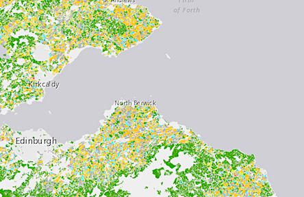
The Scottish Government said on Wednesday that crops in every field farmed in Scotland have been recorded by satellite imagery to create a new interactive map to help provide greater insight into agricultural land use.
The Scottish Crop Map uses data from 2019 to predict crop types using radar images from the European Space Agency (ESA) Copernicus Satellite Programme and to recognise the crops growing in nearly 400,000 fields in Scotland.
The map has been developed by the Scottish Government’s Rural & Environmental Science and Analytical Services (RESAS), working with EDINA at the University of Edinburgh and the Joint Nature Conservation Committee (JNCC).
Rural Affairs Secretary Mairi Gougeon said: “This map is a very exciting development and, along with other digital innovations, will provide greater insight into rural land use.
“Future iterations of the map, combined with other datasets, could have a significantly broader scope of use, providing real time data that would help with community and farm level land-use planning and management.
“The statistics we have on Scotland’s agricultural sector typically rely on surveys being completed by a large number of farmers.
“Gathering data in this way would reduce the amount of time our farmers and crofters have to spend reporting this.
“In order to help improve the accuracy of the map, and before further developments are made to track minor crops, farmers and crofters are being asked to review the current map and report any inaccuracies in the crop identified.
“Engagement with farmers and crofters with their local knowledge is vital and will help develop future iterations of the map and enable us to extend and enhance what the map could do.”
Gavin McLachlan, Vice Principal and CIO at the University of Edinburgh, said: “EDINA has been working with the agricultural sector for many years, and we were pleased to collaborate on this important project with the Scottish Government and JNCC.
“As well as providing satellite data expertise to develop the project, EDINA is also a champion of ensuring data is understood by wider audiences.
“Developing the spatial presentation of the data, to provide maximum benefit to the farming community, was an important element of the project.”
The statistics from the production of this map should initially be used with caution while the methods and techniques are still under review.
However analysis of the results predict that the model was working with an accuracy of 85% and above 90% for barley and wheat.
